


 |
|---|
 |
 |
 |
 |
 |
 |
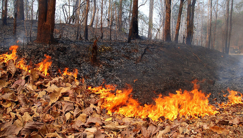
 Thermal Spring |
|---|
 |
 |
 "Isa Bulagi" |


Historical Geographical Territory
Mirza Jamal who was vizier of Garabagh khan Javanshir (1773-1853) in "History of Garabagh" (1847) work while narrates about the historical and geographical area of Nagorno-Karabakh, writes: "According to the ancient history books the border of Nagorno-Garabakh region is: from the south from the bridge of Khudaferin to Sinig Bridge is Araz River. Now (Sınıqkorpu) is among Kazakh, Shamsaddin and Demirchi-Hasanli community and the officials of the Russian state called it "Krasnı most, i.e, the Red bridge. From East is the river Kur, which joins the Araz River in Javad village, and then flows into the Caspian Sea. On the north the border of Garabakh till Yelizavetpol (Ganja) is up to the river Kura – Goran River and the Kura River passes from many places and reaches the Araz River. From the West is high Garabagh Mountains Kusbak, Salvari and Arikli. During the first period of Russian occupation and colonialism such status of the territory of Garabagh and its borders are confirmed with fact that:
1) the fact is written by the man who directly engaged in governing of Garabagh;
2) this fact is not based only on the experience but sources.
To show the accuracy of the position of Mirza Jamal his referring to ancient history books is not accidental. These facts prove that the Nagorno-Garabagh region is historical Azerbaijan area from ancient times.
Relief
The occupied Karabakh region is situated in the Lesser Caucasus, which is one of the geomorphologic units of Azerbaijan. The territory of Karabakh also gradually lowers from the northwest to the southwest. The most important geomorphologic units of Azerbaijan's occupied mountains are the Shahdag, Murovdag, Goycha and Karabakh ridges and the Karabakh volcanic plateau.
The Shahdag Ridge stretches along the Azerbaijani-Armenian border and forms a watershed between the Goycha Lake basin and the Kura River basin. The Murovdag Ridge stretches to the east of Shahdag, and its highest peak is Qamishdag (3,774 metres). The Karabakh Ridge stretches to the southwest from Murovdag, reaching the Araz River. Its absolute height reaches 2,715 metres on Mount Boyuk Kirs. The Karabakh volcanic plateau, which formed in the Cainozoic Era and has an absolute height of 2,000-3,000 metres, is situated to the west of this ridge. The surface of the plateau is covered with the volcanic lava of the fourth period, while the cones of the extinct volcano formed heights. The biggest volcanoes on the plateau are Ishiqli and Qizilbogaz.
There are five tectonic zones in Azerbaijan. Each tectonic zone has its own large terrain forms. The occupied Karabakh region forms most of the Lesser Caucasus elevation, which is one of these tectonic zones. There are many geological structures here. The Karabakh land surrounds the southeastern part of the Lesser Caucasus Mountains. Its terrain is very complex. The area has numerous high and broken mountain ridges, low mountains with even slopes, depressions between mountains and deep gorges.
The Karabakh Ridge begins from the southern part of Murovdag and stretches to the Araz River. This ridge is comprised of the Greater and Lesser Kirs and Qirkhqiz Mountains and their slopes. The Karabakh volcanic plateau covers a large area to the west of the Karabakh Ridge as far as the Armenian border. The height of the plateau reaches 3,000 metres. There are a lot of flat ridges and extinct volcanoes on it. The two cones of the Boyuk Ishiqli (3,552 metres) rise in the southwestern part of the plateau from the Armenian border. Dalidag (3,616 metres), which is comprised of acid intrusive Mesozoic rocks, is situated to the east of the lava surface.
The western part of the Karabakh volcanic plateau is exotive. The absolute height of Karabakh's lowland part varies from zero to 400 metres. Shells have formed from shield-like lava layers of the fourth period and from fragmentation resulting from physical and chemical weathering on the plains.
Mount Dalidag in Karabakh is a mountain of magmatic origin. This mountain, which is the highest peak in the Mikhtokan Mountain Range, has alpine and sub-alpine plains. Traces of ancient glaciers remain on its slopes. It is on the border between Kalbajar and Lachin districts.
Kechaldag is located in the Karabakh plateau. It is an extinct volcanic cone. Its height is 3,171 metres. It consists of Pliocene volcanic rocks. Ancient glacier terrain forms have developed on its slopes. Its height is rocky. There are alpine meadows and pearlite deposits (Kechaldag pearlite deposit) here. It is situated on the territory of Kalbajar District.
Springs
]
Our lands under the occupation are rich with natural springs. There are many mineral springs taking their beginnings from the village of Alichan, in Lachin region and appearing in the north-west. The springs Tushsu, Galaderesi, Aganush, Khirmanlar, Tigig, Tursh-digig, Nuraddin, Nagdali, Hajikhanli (Hallanli, Bashlibel -in Lachin region) assume great medical importance.
Yuhari Istisu, Ashagi Istisu, Keshdek, Garasu, Tutxun, Mozchay, Goturlusu mineral water deposits (total reserves is 3093 m3/day) made Kalbajar gain world fame are in the occupied territory of Azerbaijan and more than ten years not only Azerbaijanis but also the guests from foreign countries have been deprived of using and seeing this matchless gift of nature.
There are more than 600 natural cold and medicinal springs to be rich with minerals, in the region of Gubadli.
Water Reservoirs
There are several water reservoirs in the territory of Kharabakh which assume vital importance for the Republic. Sarsang Water Reservoir built on the river Tartarchay is an example for such a kind. It was built in 1976. Its volume is 565 mln. m³ with 14,2 km² area and 726 m. absolute height.
Khanchinchay Water Reservoir was built in 1964. Its volume is 23 mln m³, absolute height 507m, surface area 1,76 km².
Ganligol Water Reservoir situating in the absolute height is also in the Karabakh territory. Its volume is 1,0 mln m³, surface area 0,1 km², absolute height 726 m. The Reservoir was built in 1965.
Arpachay Reservoir was built in 1977 on the same named river (the Arpachay river). Source of feeding is the River Arpachay, volume 150 mln. m³, the surface area 6, 3 km², absolute height 955m.
Agdamkend Water Reservoir was built in 1962 on the river Gargarchay (at, over) the Gargarchay in 1962. Its volume is 1.6 mln. km², surface area 0.5 km², and absolute height 291.5 m.
Ecological Problems
The war unleashed by Armenia resulted not only in the destruction of cities and villages in occupied Nagorno Karabakh and surrounding districts, but also in the extermination of plants and animals in this territory and in the disruption of the environmental balance. As a result of Armenia's aggressive policy, natural reserves, forests in specially protected areas and vegetation have been devastated. Landscapes typical of Azerbaijani nature, centenarian trees, waterfalls, natural caves, cultural parks, unique geological ridges and palaeontological layers are being destroyed.
The forests that form part of the biosphere shape the animal food chain and are home to various plants and animals. The destruction of forests in the occupied territories has taken on a mass scale. It started with the brutal destruction of valuable trees in Karabakh's Topkhana woods in 1988 when Armenia's Kanaker aluminum factory decided to build a boarding house for its staff without the permission of the Azerbaijani authorities. The destruction of the forests in the occupied territories may result in the environmental balance being disrupted in that territory and ecological disasters in the South Caucasus region. The forests are being destroyed not only for military purposes. They are also being destroyed for the production of construction materials, furniture and for other purposes with the help of the military and are being transported by military hardware. Hundreds of hectares of beech, pine, oak and other trees have been chopped down in the Talish, Gulustan and Baranbart woods in the direction of Qazakh District and along the Murovdag Mountain Ridge.
Productive beech forests, which cover a large area in Agdara and Khankandi, the decorative red oak forests in the Shalva gorge of Lachin District, wonderful plane and walnut trees in the Basitchay reserve and hazelnut trees in the Kalbajar forests are destroyed en masse by Armenia and exported abroad.
Some of the eastern plane trees in the Basitchay State Nature Reserve are 1,200-1,500 years old. Their trunks are 4 metres in diameter and more than 54 metres in height. These huge trees, which have no analogues in Europe, are being brutally destroyed by the occupiers.
Armenians who have temporarily settled there use the Araz oak as fuel all year. The mass destruction of endemic species in this uncontrolled territory can be called an act of ecological genocide.
Forests, trees, shrubs and gardens south of the village of Yusifjanli in Agdam District (contact line in Agdam District) have been totally destroyed. Forests northeast of the village of Novruzlu (Agdam District) were taken away with the help of military hardware belonging to the Armenian armed forces.
The Bank Information International Centre for Strategic Studies says in its report on terror and corruption in the world:
- A reserve that occupies an area of 107 hectares in Zangilan District has almost been wiped off the face of the earth, while plane forests have been sold to Iranian furniture factories
and other construction-industrial facilities.
- Trees have been totally destroyed as a result of the deployment of Armenian military units on a 42-hectare area of the reserve;
- In 2000, 70 plane trees were sold to the governor of Tehran for 100 US dollar each;
- 110 plane trees were uprooted and transferred to the coast of the Lake Goycha (Sevan) and the suburbs of Yerevan;
- In 1995-97, 89 Armenians and 136 Persians received treatment for tuberculosis on the territory of the Basitchay reserve.
As a result of illegal road construction, mass destruction of forests, bombings and fires in this period, more than 0.5 million trees and shrubs, 152 relict species of trees, 12,197,500 hectares of valuable forest areas, 665 hectares of naturally restored forests, 75 hectares of artificial forests and five geological objects declared as natural monuments were brutally destroyed and used for commercial purposes in Qazakh, Tovuz, Zangilan, Gadabay, Kalbajar, Khanlar and Qubadli districts and in the Nagorno Karabakh Autonomous Region. Vineyards were also dried and destroyed, while concrete pillars were used for engineering and fortification work.
Radioactive waste products delivered from Armenia are dumped in the occupied territories, especially in Agdam District. A 250,000-hectare forest has been polluted with radioactive waste in Nagorno Karabakh.
The boundless high alpine meadows of Kalbajar District have changed beyond recognition. In rainy days, the Armenians go beyond major roads, driving heavy military vehicles in meadows, destroying productive pastures and causing soil erosion.
Bodies of water located in and flowing through the occupied territories (lakes, water reservoirs, rivers and canals) play an important role in the ecology not only of those territories, but also of surrounding territories. It is known that the Armenians are polluting rivers flowing through the occupied territories with various waste products and contaminated waters. The Khoneshen, Qarqarchay, Khachinchay and Tartarchay rivers originate in the occupied territories, and domestic waste is being discharged into those rivers.
The Khonashen River, which flows from the west to the east, is being polluted with sewerage and waste from the Khojavand District central hospital which is located at a distance of 200-300 metres from the river, as well as waste products from a pig and cattle-breeding complex located in that area.
The ecological condition of the Araz River, which plays an important role in the natural environment of the Nakhchivan Autonomous Republic, is even more deplorable. For example, the pollution of the river by the Armenian side for many years has killed or reduced its valuable fish population. The 21 species of fish previously registered in the river have fallen to 16 as a result of the extinction that has happened over the past 10-15 years.
Gold from the Zod deposit is purified with the help of dangerous cyanogens, while the toxic water is discharged into the Araz River. This creates grounds for Armenians to disrupt the soil, atmospheric and ecological balance in the South Caucasus region.
People who have used water from the Kondalanchay and Quruchay rivers flowing, through Fizuli District, have reported skin diseases. The reason is that the Armenians have set up a special laboratory between the villages of Seyidmahmudlu and Qarakhanbayli in Fizuli District, which is engaged in studying infectious diseases.
They study the internal organs of people suffering from infectious diseases, especially ill prisoners of war, and then release infectious remains into the Kondalanchay River, which is flowing through that territory in our direction, spreading infections. The pollution of those rivers by the Armenians gives rise to various diseases.
The technical installations of the Sarsang water reservoir are not being serviced and the water regime is not being observed. Since the water reservoir is unsafe, 400,000 people living below its level are in danger. Apart from that, since the Sarsang water reservoir was occupied, they have released 85-90 per cent of annually consumed water when it is not necessary, especially in winter.
Istisu water in the occupied Kalbajar District of the Azerbaijan Republic is bottled and sold with a label in Persian on the chemical composition of the water. The label also says that the water is from a spring in the town of Jermuk in Armenia.
The Armenian nationalists who have settled in the occupied territory of Karabakh cultivate narcotic plants and have turned this territory into a den of terror.
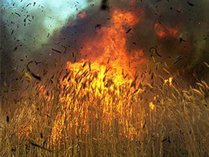
The Armenian occupiers deliberately set fire to the territory of Agdam, Fizuli, Jabrayil, Tartar and Khojavand districts along the entire contact line. The fires cover thousands of hectares of land controlled by the Armenians and at the same time, spread over to territories under Azerbaijani control, causing great damage to the environment. As a result of fires, harmful insects, reptiles, rodents and wild animals move from the opposite side to our territory and cause damage to farms. The fires destroy sawing areas and pastures and reduce water reserves.
Administrative Division Culture and Nature
Folk Craftmanship Armenian Terror
Conflict in UN Garabagh Conflict
Site map